As my new
class, Mountain Geology, has begun, last week was also the start of field trips
to rocky, volcanic locations such as Quilotoa. Leaving early Thursday morning
we drove along the Pan-American Highway into the Cotopaxi Provence, where we
passed numerous signs that stated “Volcano Threat Zone” along the way. Entering
the Inter-Andean Valley we drove through Latacunga, a smallish city about 1.5
hours south of Quito, and drove up into the Western Cordillera. The
Inter-Andean Valley runs from Riobamba in the south all the way to the frontier
with Columbia and used to be much more of a valley. It has been filled with
sediment from erupting volcanic eruptions over hundreds of thousand of years,
specifically Cotopaxi.

After driving
through Latacunga, we passed numerous quarries and were told these were ash and
pyroclastic rock deposits from the Chalupas Volcanic eruption 200,000 years
ago. These quarries were more than 50km away from Chalupas, and the eruption
left ash deposit on the coast 300km away that was 4m thick. No wonder there are
Volcano Threat signs everywhere.


West to
Latacunga is a large field called the Macuchi Unit that is part of the Western
Cordillera and contains an old volcanic arc 40-60 million years old that used
to be in the ocean (cool, right?!). This 90-200 million year old large igneous
province (LIP) was accreted with the continent when the Nazca plate subducted
under the South American plate a very long time ago.


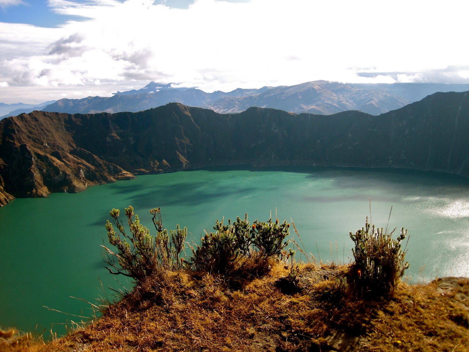
The pyroclastic
flow that was deposited by the Quilotoa eruption 800 years ago had a total
regional deposition of 18km3. This ash and pyroclast can still be
seen today in quarries, as well as when hiking along the rim of the volcano.
The magma from Quilotoa contained the minerals biotite, plagioclase, and
quartz, meaning it had a high silica and water content (5% is high for water
content). A high silica and mineral content makes the magma more viscous,
causing the lava to erupt similar to toothpaste, creating a lava dome in the
center of the volcano. A high water content, on the other hand, creates
numerous bubbles, and therefore explosions. What’s cool about Quilotoa is that
during one its eight explosions, a lava dome was created, but then later on
exploded, creating the caldera we walk upon today. You can still see a few of
the walls from the old caldera. Quilotoa has very grand eruptions once every
10,000-15,000 years, creating mass havoc and rearranging the landscape as she
so chooses.


When we
finally arrived to Quilotoa, Ben, my 31 year-old professor, told us that if we
could climb out of Quilotoa from the Laguna back up to the rim within 30mins we
were ready for Cotopaxi. So we ‘hiked’ (it was more like slide) down a steep
path of volcanic ash (imagine running through dry sand on the beach, it was
kind of like that, but on an incline). Making our way down the avalanche slope
in 25 minutes, we all doubted our ability to hike back up within 30. Four girls
and Ben did make it up in 30 minutes meaning…they’re ready for Cotopaxi!

I made it up within 38 minutes, so maybe I’m not entirely ready, but my determination and Jackie’s positive attitude will get me to the top! We ended the evening with wonderfully hot showers, herbal tea, and a dinner to top the night off.


I made it up within 38 minutes, so maybe I’m not entirely ready, but my determination and Jackie’s positive attitude will get me to the top! We ended the evening with wonderfully hot showers, herbal tea, and a dinner to top the night off.

Because the
buildings are all made of brick, there aren’t any heating systems, just a wood
stove in each room. The wood stove in the room I was assigned to seemed to have
some issues, as the smoke wasn’t leaving via the air duct, but coming into the
room instead. I don’t know what it is with me and wood stoves, but whenever I’m
near one it doesn’t seem to want to work (Kristen: Anderson Valley in Northern
Cali, haha). Well, I wasn’t about to go to bed cold so I crashed another room
and practically drenched my clothes with sweat the room was so hot. Hmmm, happy
medium?

Awaking bright
and early (although a little tired) to the sun shining through the windows we
got our things together and made our way down to breakfast. My professor Ben
(did I mention Ben is actually younger than me?! It’s really difficult to take
his mandatory attendance policy seriously) wanted to get an early start, so by
8am we were up and walking to the rim of the caldera. Our plan was to walk
along the entire rim of the caldera and stop and talk about rocks and rock
formations. This was supposed to take approximately 5 hours and include a
summit of Quilotoa.


Well, ever tried walking on sand uphill? That’s what it was like hiking along the rim of the caldera, except it’s the ash from the 800 year-old volcanic eruption that you’re trying to make your way through as you’re climbing a mountain with a 30-degree slope. Just a tad tiring.

Summiting Quilotoa was such a rewarding experience, only to be followed by some lecture on volcanic hazards with the wind blowing at our backs and practically pushing us over the rim to the Laguna far below. Why we couldn’t have spoken about volcanic hazards in class is beyond me. Maybe it’s more exciting with death knocking at your door? When we were almost halfway around the Laguna when we discovered we were missing one student, who apparently turned around and went back to the hostel b/c she wasn’t feeling well. Now, I totally understand not wanting to hike if you’re sick, and I understand Ben’s wanting to turn around to make sure she was okay. The only issue? We had already summited Quilotoa and gotten through the worst part, only to have to return and do it all over again. I really prefer to walk into the unknown and take things as they come, but knowing how hard the hike is and having to do it again? No bueno.

Thankfully, after 2 hours, tons of sweat, numerous explicatives, and considering calling a helicopter to come and pick me up, I made it to the GPS marker. The GPS marker, really just a big carved rock, basically means the worst is over, so you can imagine the feelings of gratitude and happiness I felt when I reached it. I have a feeling summiting Cotopaxi will be similar, but with a greater intensity of feelings and tears. We finished out the hike with lunch at the hostel and a long 4-hour bus ride back to Quito. Along the way we drove by Cotopaxi surrounded by clouds, staring menacingly at us and daring us to attempt her summit.

In preparation for Cotopaxi I've been running at least one hour pretty much everyday. Yesterday a few fellow Cotopaxi trainers and I went up Teleferico in a Gondola (that experience alone was exciting and rough, especially with my fear of heights, which I'm pretty sure is more like a fear of falling) with the intent of summiting Mt. Pichincha (an old dormant Volcano). The elevation at the summit of Pichincha is around 4650m. We easily made it to our marker on the trail from our previous hike in less than half the time! It was very cloudy so we didn't get to see Cotopaxi or the other volcanoes, but the view was still beautiful with the clouds rolling in. That and the people practically running down the mountain should have caused us to turn around, except we didn't. We were practically at the summit and it was so foggy we couldn't see where the trail continued so we decided to turn around. We made it to that point in only 1hr 45min! How awesome is that! A 5K with a 600m elevation change in 1hr 45 mins?! Super exciting. Speaking of exciting events, as we turned around and started hiking back to Teleferico we heard thunder (oh no!) and then it "rained". Except rain at an elevation of 4600m in more like small ice balls. They're pelted at you form the clouds and the feel like bebe's from a bebe gun. I've got a few bruises to prove it. Thankfully, back in Quito it was only raining, which is strange because this is Quito's dry season and it's rained 2x this month. Only two more days til Cotopaxi!
No comments:
Post a Comment